

Surveying has always been a blend of science, technology, and art. From ancient Egyptians using ropes and geometry to modern surveyors wielding advanced laser scanners, the quest to measure and map our world accurately is as old as civilization itself. Today, this field is undergoing a significant transformation, driven by the rise of drones and satellites. These technologies offer unprecedented accuracy, efficiency, and insight, enabling surveyors to capture data from angles and altitudes that were once unimaginable. Central to this technological leap is the integration of sophisticated tools like the RTK IMU receivers, which enhance the precision of geospatial measurements.
The RTK (Real-Time Kinematic) IMU (Inertial Measurement Unit) is a critical component in modern surveying equipment,. It combines real-time satellite positioning with inertial sensors that track motion and orientation. This dual capability allows surveyors to obtain highly accurate 3D spatial data, even in challenging environments where traditional surveying methods might struggle.
Precision Surveying on the Ground and in the Air
Surveying has entered a new era, where high accuracy and rapid data collection are no longer confined to traditional methods. Today, professionals can choose between—or combine—two powerful tools: drones equipped with RTK IMU technology and hand-held GNSS receivers with the same capabilities. Both options deliver centimeter-level precision in positioning, revolutionizing how data is gathered across industries like construction, mining, agriculture, and environmental monitoring.
The Role of RTK IMU Technology
At the heart of this transformation is RTK (Real-Time Kinematic) combined with IMU (Inertial Measurement Unit). RTK uses corrections from a base station or network to achieve real-time, high-precision positioning. IMU provides information about orientation, motion, and tilt, stabilizing readings in challenging conditions.
Whether mounted on a drone or held in hand, RTK IMU allows surveyors to gather spatial data that’s both highly accurate and reliable—even in areas with poor satellite visibility or difficult terrain.
Hand-Held GNSS: Mobility and Control in the Field
Hand-held GNSS receivers enabled with RTK IMU offer surveyors unmatched mobility and granular control. These devices are ideal for ground-based surveys, allowing users to physically inspect, measure, and mark points with precision. They shine in environments where drone use is restricted—dense urban areas, forests, or indoor-outdoor transition zones.
The IMU component ensures continuous accuracy even when the receiver tilts or shifts during use. This stability reduces the need for stopping to recalibrate, enabling faster workflows and more consistent data quality.
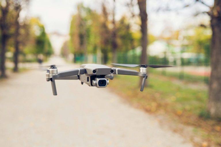
Drone Surveying: Speed, Safety, and Scale
Drones, by contrast, bring speed and coverage to the equation. Equipped with RTK IMU, they can fly over large or hazardous areas, capturing thousands of georeferenced images in a single flight. These images can then be processed into 3D models, elevation maps, and orthophotos—making drones indispensable for topographic surveys, construction site monitoring, and infrastructure planning.
The IMU component in drones helps correct for turbulence, sudden gusts, or flight angle changes, ensuring that the data remains consistent throughout the mission. What once took ground teams days or weeks to survey can now be completed in hours.
A Hybrid Approach: The Best of Both Worlds
Rather than choosing one over the other, many professionals are now combining drone and hand-held RTK IMU tools in a hybrid workflow. For example, a drone can be used to scan a construction site and create a high-resolution orthomosaic, while a hand-held receiver is used to mark control points, measure tight spaces, or verify elevation values.
This integrated approach allows surveyors to cross-verify data, fill in detail where drone coverage is limited, and align close-range measurements with large-scale aerial data. When both sources use the same RTK IMU foundation, the datasets align seamlessly, reducing the need for corrections during post-processing.
Advantages in Complex Environments
Both drones and hand-held receivers contribute to surveying in complex or sensitive environments. In archaeological sites, for instance, drones can map the area without disturbing the ground, while ground crews use hand-held GNSS to mark artifact locations. In wildlife reserves, drone flights minimize human intrusion, and hand-held tools allow for selective, targeted measurements.
In industrial settings, like mining or construction, drones keep surveyors out of hazardous zones, while hand-held devices ensure high accuracy near structures, equipment, or where GPS signal quality fluctuates.
Historical Context and Remote Monitoring
While drones and receivers excel in real-time surveys, RTK IMU technology also supports long-term monitoring and change detection. Hand-held GNSS units can be used for repeatable, time-stamped measurements, while drones revisit sites at set intervals to track changes. These records are especially useful in monitoring slope stability, infrastructure wear, or gradual environmental changes.
In more remote areas where drones are restricted or unfeasible, hand-held receivers remain a reliable solution. Their portability makes them valuable for reconnaissance and site assessment, even where terrain, vegetation, or regulations pose obstacles.
Unlocking Predictive Power Through Combined Data
When the high-detail data from drones is fused with ground-level precision from GNSS receivers, surveyors gain the ability not just to measure, but to predict. Overlapping current survey data with previous records reveals trends in land movement, erosion, or land use patterns. In agriculture, combining drone-based crop imagery with soil measurements taken via hand-held RTK GNSS supports yield forecasts and irrigation planning.
Such predictive capabilities depend on the synchronization of spatial data, which is made possible by RTK IMU ensuring consistent positioning and orientation across all data sources.
Toward Automation and Real-Time Analysis
Looking ahead, the evolution of surveying is pointing toward increased autonomy and automation. Drones will likely carry out routine flights, feeding data into cloud systems in real time. Simultaneously, hand-held receivers will continue to be used for spot checks, troubleshooting, and detailed ground validation.
The integration of AI and machine learning with RTK IMU-equipped tools enables near-instant interpretation of spatial data. Algorithms can identify anomalies, classify terrain types, and even detect construction errors or environmental risks—freeing up human experts for higher-level decision-making.
One Ecosystem, Multiple Entry Points
The key to modern surveying is not in picking one technology over another, but in recognizing that each tool complements the other. A hand-held RTK IMU GNSS receiver is not a fallback when a drone isn’t available—it’s an essential instrument that can gather data where aerial access is impossible or imprecise. Likewise, drones aren’t just time-savers—they’re strategic assets that add context, depth, and scale to any surveying operation.
This synergy supports more agile, informed decision-making, which is crucial in industries where margins for error are razor-thin and timelines are tight.
The Future Is Grounded—and Flying
As RTK IMU technology becomes more accessible, surveyors will continue to refine how they use both drones and hand-held receivers in their daily workflows. With improvements in battery life, connectivity, and onboard computing, the barrier between manual and automated surveying is thinning.
Ultimately, what emerges is a system where the ground and the air work in harmony. Surveyors can move fluidly between tools, collect exactly the data they need, and deliver high-quality results faster and more safely than ever before.
